


We've just launched our seeCrop agronomy app...
seeCrop allows satellite imagery to be viewed on your smartphone or tablet while out in the field. This imagery can be used as a crop walking aid to help identify areas of crop damage or stress.
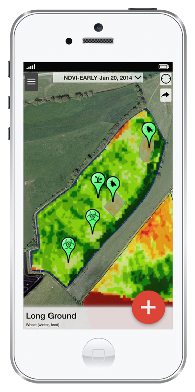
Once problem areas are identified seeCrop allows you to record the precise location either as a point or a polygon drawn around the area. The app comes pre-loaded with over 260 of the UK’s most common pests, weeds and diseases and will predict what you are most likely to see depending on crop and time of year.
The potential benefits of the seeCrop app have been recognised by the European space sector. In 2014 seeCrop was crowned UK champion of the European Satellite Navigation Competition (ESNC) and has been developed with help from the European Space Agency as part of their Business Incubation programme.
seeCrop is available on iTunes or Google Play
Click here to watch a video of the app in action or go to the Rhiza website to find out how to get set up.
seeCrop allows satellite imagery to be viewed on your smartphone or tablet while out in the field. This imagery can be used as a crop walking aid to help identify areas of crop damage or stress.
Once problem areas are identified seeCrop allows you to record the precise location either as a point or a polygon drawn around the area. The app comes pre-loaded with over 260 of the UK’s most common pests, weeds and diseases and will predict what you are most likely to see depending on crop and time of year.
The potential benefits of the seeCrop app have been recognised by the European space sector. In 2014 seeCrop was crowned UK champion of the European Satellite Navigation Competition (ESNC) and has been developed with help from the European Space Agency as part of their Business Incubation programme.
seeCrop is available on iTunes or Google Play
Click here to watch a video of the app in action or go to the Rhiza website to find out how to get set up.
Last edited by a moderator: